History of the Gravel Pit and Pond
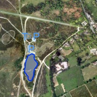
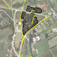
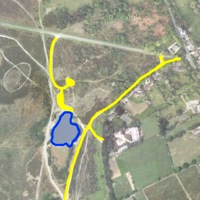
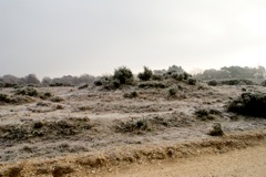 The aerial photo (left) shows the Present Day pond area outlined. "P" marks the car park areas and "T" marks the prehistoric burial mound (see photo right).
You can View a Map Sequence showing the area of the gravel pit and the surrounding tracks at various times in the past superimposed on the present day aerial photo.
The aerial photo (left) shows the Present Day pond area outlined. "P" marks the car park areas and "T" marks the prehistoric burial mound (see photo right).
You can View a Map Sequence showing the area of the gravel pit and the surrounding tracks at various times in the past superimposed on the present day aerial photo.
 The gravel pit is marked on the 1868/1871 Ordnance Survey map in the area between Jealous Lane and the minor road towards Sway. It is shown as mostly overgrown. Possibly the pit had been created during the construction of the nearby Brockenhurst to Lymington railway (opened 1858), or it may date to earlier years. At that time the area of the present day pond was open heathland.
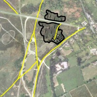
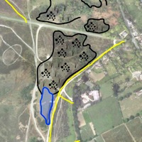
 By the 1897/98 the gravel pit had extended southwards and westward (was gravel from Setley used to construct Sway Tower ?) until by 1909 it occupied the region shown on the map (right).
Maps from the 1930's were based on mapping in 1919 but show the same area of gravel pit as in 1909. This implies that there was no pond at Setley following World War 1, or in the years before World War 2.
By the 1897/98 the gravel pit had extended southwards and westward (was gravel from Setley used to construct Sway Tower ?) until by 1909 it occupied the region shown on the map (right).
Maps from the 1930's were based on mapping in 1919 but show the same area of gravel pit as in 1909. This implies that there was no pond at Setley following World War 1, or in the years before World War 2.
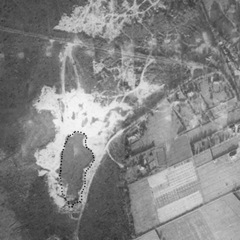 This aerial photo was taken in December 1946. It has been stated that gravel excavation at Setley during WW2 was for the construction of Stoney Cross airfield (e.g. see New Forest Explorers Guide), but the closer Lymington Airfield, Beaulieu Airfield, or the local Setley Plain Prisoner of War Camp seem more logical explanations.
 By 1962/63 the gravel pit is shown as disused and, for the first time, a pond exists! The pond outline seems to be crudely indicated on the 1" map. Possibly it was very shallow before it was deepened in the 1970's with the start of model yacht racing.
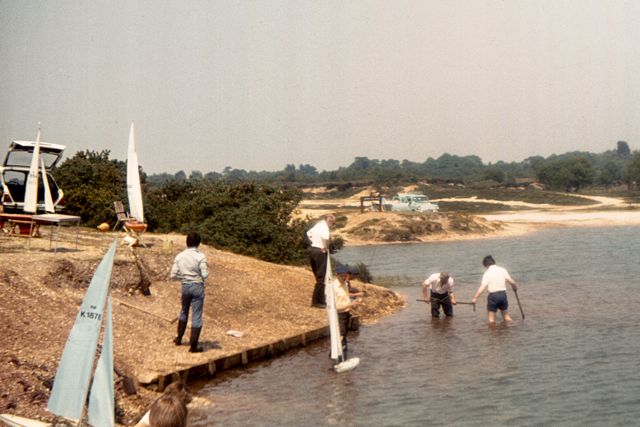
 By 1970/72 the pond was shown at its present day extent but the gravel pit was no longer marked on the map. This corresponded to the Early Club Days when it was possible to drive cars freely on the various tracks around the pond (see photo right).
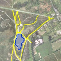
 By 1972/74 the present day car park layout is shown. Only the area of the pond north of the island is marked as water and this is how the pond is marked on some maps up to the present. Presumably the pond level was low when the survey was done!
(Information on this page is based on the following Ordnance Survey maps (scale, inches to 1mile): 1868 (2.5"), 1871 (6"), 1897 (2.5"), 1898 (6"), 1909 (2.5"), 1910 (6"), 1919 (1"), 1930 (1"), 1962-63 (6"), 1970-72 (2.5"), 1972-74 (6.25"), 1972-94 (6.25"), 2004 (2.5"); old OS maps are available at old-maps.co.uk; the aerial photo used as background is © Google 2011 Thanks to Richard Reeves, Librarian at the New Forest Centre, Lyndhurst for some of the data used)
[Back to previous page]
|